I am now going to introduce you a detailed description of the Around Annapurna trek, with a recommended plan how much to walk every day. This is the exact way my friends and I walked this trek, so it is well tested.
All the times mentioned in “Timing” include resting time and meals-time. In general, these timings refer to a quite easy pace of walking.
Day 1 – Pokhara – Begnas Bazar – Karputar
Take a taxi from Pokhara to a village named Begnas Bazar (on some maps a place called Sisuwa is marked). It’s a 20 minutes ride from Pokhara. Say goodbye to roads and motor-vehicles, and start walking in the most amazing trail you have ever seen.
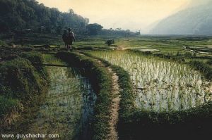
This village is located just south to Begans lake, so the trail goes south and above Begnas lake, in an altitude of about 700 meters. It’s a green lash area, with some small villages scattered around. The beginning of the trail is on a ridge and gives you a great view of the area below, injecting strong motivation for the whole trek. Next, you’ll walk between small streams and cute rice fields.
After noon you’ll reach Karputar, a nice village lies next to a river called Madi Khola, where you can wash after your first walking day.
Villages on the way: Tarbesi, Sakkara Bhanjyang (you can eat there).
Timing – Begnas-Bazar to Sakkara – 4.5 hours. Sakkara to Karputar – 2.5 hours.
Day 2 – Karputar – Nalme
From Karputar you’ll keep walking between rice fields and small villages .You’ll reach another river called Midim Khola, and then expect a bit difficult ascend of about 600 meters (don’t worry, it is a good path, and there are even stairs on some places) to Nalme – located 1250 meters high, on a beautiful ridge.
It is the first time you can see the Annapurna mountains, still far from you – but give you a strong will to get there …
Timing – Karputar to Nalme – 6.5 hours.
Day 3 – Nalme – Baglungpani – Khudi – Bhulbhule
From Nalme you continue to ascend towards Baglungpani – 1620 meters high. The area is full of trees, and the view from this high area is remerkable. After Baglungpani it is a long descend towards Khudi, 800 meters high. Khudi is located on the Marsyangdi river – the huge river you’ll walk along in the next days until the pass. It is also the place where you’ll meet all the other trekkers who started in Besi Sahar.
You can sleep at Khudi, but we recommend to continue a little further to a place called Bhulbhule, and find a guest-house there. It is located just near the river, with the great sound of the rumbling water…
Timing – Nalme – Baglungpani – 3.5 hours, Baglungpani – Khudi – 4 hours, Khudi – Bhulbhule – 0.5 hour.
Day 4 – Bhulbhule – Bahundanda – Sange
Walking in the trail along the Marsyangdi river is quite easy most of the way. After descending to Khudi and reaching the Marsyangdi it is now a gradual descend up this river. The mountains on both sides of the river are amazing, with tiny villages located on top of them.
From Bhulbhule walk to Nagdi (where you can eat good food) and then to Bahundanda (1310 meters). In Bahundanda there are some shops to buy groceries, camera films (still in a reasonable price) and there is even a telephone. After Bahundanda walk to Sange, where we recommend to spend the night.
Timing – Bhulbhule – Bahundanda – 4.5 hours, Bahundanda – Sange – 3.5 hours.
Day 5 – Sange – Jagat – Tal
From Sange go to Jagat, which is located 1250 meters high. Then the path climbs towards Chamche, 1430 meters high. After Chamche the Marsyangdi river creates a small vally, in which Tal is located – 1675 meters high. Tal is a village that looks like a town from a western-movie. The people who live in Tal are some-how strange, but we had a good time there. You can buy there all kinds of goodies, and there is a nice waterfall just near the village.
Timing – Sange – Jagat – 1.5 hours. Jagat – Chamche – 2 hours. Chamche – Tal – 2.5 hours.
Day 6 – Tal – Dharapani – Bagarchap – LaThamanag
Walk from Tal to Dharapani (located 1900 meters high). From Dharapani you’ll reach Bagarchap. On November 1995 a land slide ruined the village, killing locals and tourists. Continue a little further, and you’ll reach a place called La-Thamanang. Located 2300 meters high, it is hardly a village – just some houses and guest houses on the main trail, but – There are wonderful hot springs just near this place! Put your things there, and go for a wash in the hot springs – while you are surrounded by huge snowy mountains!
Timing – Tal – Dharapani – 2.5 hours, Dharapani – LaThamanang – 3.5 hours.
Day 7 – LaThamanang – Koto – Chame
This is a short and easy walking day. Walk from LaThamanang to Koto, and pass it to reach Chame.
Chame is a big village, where you can find many shops, guest houses, police station, a clinic and a bank.
Located 2700 meters high, you can already see some of the big peaks of the Annapurna above you.
Go to the far part of the village, and cross the bridge to “New-Tibet” guest house.
Timing – LaThamanang – Koto – 2 hours. Koto – Chame – 1 hour.
Day 8 – Chame – Bhratang – Pisang
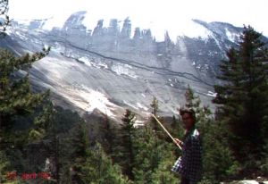
This is a beautiful walking day in an area of heavy woods. When you reach Bhratang area, you’ll be able to see an amazing cliff called “Paungda Danda”, 1500 meters high above the river and the path. After you leave the woods area you enter a large valley, taking you towards Pisang. Pisang is divided to two parts. The lower part of Pisang is located 3190 meters high, and contains many guest houses. The upper part of Pisang is located 100 meters above, it is more interesting but there are no guest houses there. The area around Pisang is amazing, the view of the mountains around you is mind-boggling, and it is recommended to stay there another day just to rest, get used to the heights, and enjoy the lovely sights.
Timing – Chame – Bhratang – 2.5 hours. Bhratang – Pisang – 3.5 hours.
Between Bhratang and Pisang there’s a nice motel-guesthouse with good food.
Day 9- Pisang – Ghyaru – Manang
From Pisang to Manang there are two ways.
The first one goes along the Marsyangdi river, but – it is more boring. The recommended way is to climb up to a village called Ghyaru, and the descend back to Manang. It is quite a hard climbing, but it is worth it – the panoramic view from Ghyaru is spectacular!
And – Ghyaru and another village you’ll reach on this way are really special.
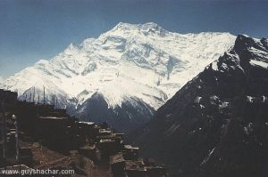
It is a long walking day, but the view on the way is amazing. The peaks of Annapurna II (7937 meters), Annapurna IV (7525 meters) and Annapurna III (7855 meters) are just above you, as if you can touch them. These peaks are covered with heavy snow, while the other side of the river looks dry like a desert! Really outstanding.
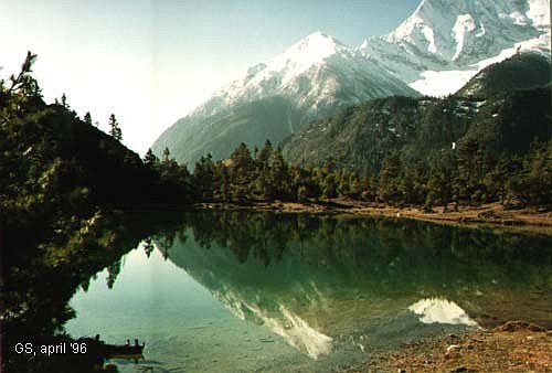
So – from Pisang you climb towards Ghyaru (3670 meters). On the way you’ll pass an amazing little “green lake”. After Ghyaru you reach a village named Nawal. From there you get to Manang, 3300 meters high.
Timing – Pisang – Ghyaru – 2.5 hours, Ghyaru – Manang – 5.5 hours.
Day 10 – Manang
After the hard day you had getting to Manang, you’ll have to rest there for acclimatization.
There’s a western clinic in Manang, with volunteers that treat the locals and advises about awareness to mountain sickness. It is recommended to attend the daily briefing they give about mountain sickness.
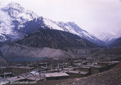
Manang itself is beautiful. Unique houses all built from stones and wood, the enormous mountains above, a charming lake (frozen in the winter), and lovely people and cute children. When you are in Manang you can go for short walks around.
There are plenty of guest-houses and shops in Manang, where you can buy groceries and some other useful staff. We recommend sleeping in “Tili cho” guest house – they have excellent food – both local and western.
Day 11 – Manang – Yak-Kharaka
The way from Manang takes you upper to the origions of the Marsyangdi river – you’ll reach the adjoining of “Khangsar Khola” and “Jhargeng Khola”, where they turn into the big “Marsyangdi” river. From now on you’ll walk up the Jhargeng Khola (until Thorung-La pass).
From Manang you pass Gungsang and reach Yak Kharka – 4000 meters high. It is not even a village, just a place with some guest houses for travellers. Go to “Gangapurna” guest-house. Good food.
Note that on those heights, you already feel the low density of the air. Every step requires more effort, and you need to rest many times during walking – Take it easy, don’t rush! This is the key for avoiding mountain sickness. And – drink a lot, even when you’re not thirsty.
Timing – Manang – Gungsang – 2 hours. Gungsang – Yak-Kharaka – 2 hours.
Day 12 – Yak-Kharaka – Churi-lattar – Thorung Phedi
This day you walk towards the last station before the great mountain pass. You walk to Churi-lattar (4250 meters), which offer some guest houses and tea-houses, and then reach Thorung Phedi – 4500 meters high.
In Thorung Phedi there’s only one guest house, and it is recommended to get there early to catch good rooms to sleep in. In the touristic season or incase the pass closes, the place is quite full. They have real good food there, and you should eat well, to gain power for the most thrilling day of the trek – crossing the “Thorung-La” pass.
Timing – Yak-Kharaka – Churi-lattar – 1.5 hours. Churi-lattar – Thorung Phedi – 2.5 hours.
Day 13 – Thorung Phedi – Thorung La Pass – Muktinath
This is the day of the trek. Get up early, and start walking at about 4 or 5 a.m.
Take lots of water, and your warmest clothes.
It is about 900 meters of climbing to the pass – from 4500 meters to 5416 meters. In the spring and after the summer the trail should be quite clear, but after snow storms the way could be confusing.
It is recommended to cross the pass in a big group, of at least 4 people.
There’s one tea house on the way, at about 5000 meters, and believe me – you’ll need it.
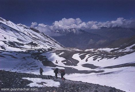
Most of the walking is in the snow, surrounded by snowy mountains all over. Walking is difficult, and you’ll stop every 10 steps to breath as if you just ran 2000 meters .
On the other side of the pass it is really “another world” – the landscape changes dramatically from snowy mountains to dry yellow-brown cliffs, area that looks like a desert.
Going down after the pass is also an uneasy task. It is a descend of 1600 meters, which really makes your knees cry. Finally you’ll reach Muktinath, 3800 meters high.
There are plenty of guest houses in Muktinath, with really good food, and some temples worth visiting – Actually Muktinath is one of four major places of pilgrimage for Hindu people in the Himalayas, and it is also sacred to Buddhists.
Timing – From Thorung-Phedi to the tea-house – 3 hours. From the tea-house to the pass – 2.5 hours. From the pass to the next tea-house – 3 hours. From the tea-house to Muktinath – 2 hours. Total – over 10 hours.
Leave a Reply